To clarify, this was not a 'proper' hot air balloon ride, but I had never been in a hot air balloon before anyway, and it was free, and it gave a completely different perspective of the UNM campus. As such, I rose early to make the dawn ride, which provided the added bonus of seeing a beautiful sunrise over the Sandia mountains to the east of the city.
 |
| Sunrise over the Sandia mountains |
 |
| An aeroplane appears to chase birds, illuminated against the sunrise |
 |
| The hot air balloon |
 |
| Enjoying the view from the basket |
 |
| An unusual bird's eye view of UNM campus |
The second experience, which is of far greater significance than the balloon ride, was a weekend-long road trip with four friends to the nearby state of Utah to explore some of North America's finest landscapes. Some of the plans had been set out well in advance, but by and large it was a reasonably spontaneous trip, departing on Friday afternoon once all our classes had finished, and returning on Sunday evening.
Having rented a car and loaded it with five people's clobber, we set off north, initially along Interstate 25, but we then left it for Route 550 and remained off the Interstates until the final part of the return journey. There is very little between Albuquerque and Farmington near the Colorado border, but we were all struck by the natural beauty of the New Mexican landscape, which made a noticeable change from the environs of the city. The slowly setting sun added an extra dimension to the attractive but empty countryside, and by the time we reached the town of Farmington, darkness had well and truly descended.
After only brief stops, we pressed on and soon crossed into Colorado - I had previously spent a few hours in Denver airport on the way to New Mexico, but due to the dark of the night, I saw little of the Centennial State. Around the time we entered Colorado, we began to notice lightning ahead of us, and quickly observed it striking the land to the left and the right, and before long we were surrounded by lightning on all sides, although pleasantly there was no lightning nor even rain in our vicinity. I had read about the recent flooding in the southwest of the state in the news, but there was no hinderance to our progress, and neither was there any indication that there had been any flood damage in the area we travelled through at all.
With lightning still raging on all sides, we left Colorado and arrived in Utah, travelling west to start with but soon turning north once we reached Monticello, only the sixth settlement of any note since we had started. Moab, the seventh and final town, lay ahead and all seemed well. At this point, the storm finally caught up with us and we were engulfed by heavy rain, thunder and lightning. Moab is not a large town - it actually calls itself a city despite boasting only 5,000 inhabitants - and it is straightforward to navigate, being arranged in a linear fashion along Route 191 with only minor roads branching off. Despite this, we were forced to circumnavigate Moab several times before at last stumbling across the hostel I had identified as offering a good price for our party of five.
Weary and disorientated, our group abandoned the car and trudged into the night, through a rickety door into a decrepit building, relieved to be free of the rain and ready to settle down for the night. Like a scene from a gothic film, a man, face haggard and worn, slowly raised his head behind the counter, revealing a single eye, the other socket bloody and deformed. At precisely this moment, lightning flashed outside, the electric glow reflecting off the back of the proprietor's empty eye socket, and he announced in an uninterested monotone, 'We have no room.' Our faces stunned, he returned to his crossword without so much as a whisper, leaving us to see ourselves out and seek alternative accommodation.
This was undoubtedly our lowest ebb of the entire trip, for Moab's tiny population appeared to have strategically booked itself into every single room of the numerous motels, hotels and hostels that constitute the small town. We quickly established that there was no room at the inn, but being as we were in a state founded by Christian pioneers, it seemed only logical that there would be a stable instead. Ninety minutes later, having irritated Moab's petrol station owners, trespassed our way across what felt like every byway eastern Utah had to offer and even discussed continuing as far as Canada to see if they had space, we arrived at our metaphorical stable.
This was one of several small campsites situated on the banks of the Colorado River just outside Moab, and even this was not ideal. With no vacant pitches, we were consigned to share a spot with two young men from Colorado, who permitted us to park beside them and even gave us water, before offering us whatever assistance we needed on the grounds that they were 'not here to hurt you, or murder you.' Precisely the words one would expect a potential murderer to use, and hardly reassuring when we'd already been forced out of town by circumstance, been caught in a heavy thunderstorm and arrived in an unfamiliar environment late at night with our focus solely on settling down into whatever position in the car was most comfortable and getting whatever sleep we could.
Dawn broke, and with an immense sense of relief, I came to the realisation that I had not been slaughtered in my sleep, and was instead looking out into an impressive canyon of red rocks, none of which had been visible in the darkness of the previous night. A short leg-stretch also revealed the deep brown colour of the Colorado River. The sense of being a North American pioneer, alone and undisturbed in the midst of an alien landscape, was very fitting. And with that poignant thought stuck in my head, we went into Moab to buy food at a supermarket, truly embodying the pioneer spirit.
Following our breakfast and supply stop, we drove a short distance to Arches National Park, a natural landscape containing a vast number of enormous sandstone rock formations and one of Utah's most scenic locations. Arches is positioned on a plateau above the town, and once we had climbed up into the park, we were confronted with a landscape very different from that down in the valley below. The park is broken up into sections according to the most prominent rock formations found there, and the first stop was the Courthouse Towers. Here we admired the landscape and went for a two-mile walk, all the while taking in rock towers like the Three Gossips, the Sheep and the Organ.
After leaving Courthouse Towers, we drove on towards the middle of the park, where our next stop was The Windows Section, which contained the remarkable Balanced Rock as well as several spectacular arches and windows.
Another short drive took us through the Fiery Furnace section of the park to the Devil's Garden, right at the north end of Arches. Here we went for a walk (which also involved scrambling up and down rocks close to deep gorges) through the most incredible landscape of the day; large sections of Devil's Garden could have been the set of a science fiction film! There was a little rain when we set out, but thankfully, the sun emerged from the clouds, revealing unique red rock formations, the plains of Utah and the mountains of Colorado in all their splendour. It is extremely tricky to attempt to describe this landscape; it was simply the most spectacular, surreal environment imaginable, and I will let the pictures do the talking!
Reluctantly, we left Devil's Garden after a lengthy exploration of the area, in order to view the sunset from Arches' most well-known landmark, Delicate Arch. To our great disappointment, though, the road leading to the arch was cordoned off and a US Park Ranger politely informed us that the road was impassable even for walkers. Fortunately, she did offer us some consolation in the form of a viewpoint from which we could see the arch, but even then, the sight was much less impressive than it would have been close up.
Since we still had around ninety minutes of daylight remaining (having allowed time to complete the walk to Delicate Arch), we elected to return to the Windows Section as there was another accessible arch formation that we had not visited, as well as an excellent vantage point to the west from which to watch the sunset. Thus, we walked to Double Arch, where we sat in the quiet of a cave-like area (albeit with an open top) and reminisced about the day and our adventure thus far.
Finally, we ambled over to Turret Arch and perched upon a rocky ledge, we saw the sun go down. I cannot speak for the others, but for me it was the single most beautiful natural phenomenon I have ever witnessed. In those brief minutes, I reflected upon how small man is in this world. For only one thing I could see had changed upon that sparse scene in the last several million years - the man-made road that snaked across the landscape. A Mormon pioneer arriving from the east in the 1850s, a Spanish missionary in the 1770s or a native Ute in the 1000s could have witnessed a carbon copy of that sunset save for the road that enabled me to see that event. Even in the last period of the dinosaurs' tenure on Earth, Arches National Park would not have looked radically different from today. In that time, arches would have collapsed (such as Wall Arch in 2008) and countless new ones would have been formed.
This gave me hope that even though the less stable arches (like the incredibly thin Landscape Arch) will collapse, many of today's small caves will have eroded into new arches, so that in another hundred, thousand or even million years, there may still be humans (or other intelligent life forms) able to appreciate the natural splendour of this unbelievable place. As mentioned briefly already, the state of Utah was founded by religious pioneers, members of The Church of Jesus Christ of Latter-day Saints, and whilst their theological doctrines are unconventional within Christianity, it was difficult not to feel, in some small sense, that this place truly was God's country.
After leaving Arches, we drove south into the night, in order to reduce the travelling distance the next day. Before too long we reached Monticello, and soon afterwards we pulled off to stay at another campsite, just off Route 191. As we had already slept rough one night, we had no qualms about repeating the arrangement, and soon settled down for a second night in the car, this time with no hidden surprises such as canyons, lightning storms or potential murderers.
The day began with oppressive cloud and there was heavy rain during our breakfast stop in the town of Blanding, but this subsided as we followed the sun towards the south, and by the time we reached Bluff, the day was glorious. We followed Route 163, a designated scenic byway, through more amazing red rock desert and the charmingly named village of Mexican Hat, until the jaw-dropping sight of Monument Valley presented itself before us. After Arches, it was hard to comprehend that any sight could be in the same league in terms of natural wonder, and yet Monument Valley defied the odds!
The turning leading to Monument Valley is still in Utah, but the visitor centre itself is in Arizona, and somewhere along the road that enters the park, we crossed the border into my fifth state. Unfortunately, the attendant at the entrance informed us that it would not be possible to access the valley floor in anything less than a 4x4, so we headed to the visitor centre to decide upon a plan. The information boards made some reference to the fact that the park fell under the Navajo Nation, an area of land returned to native Navajo control by the US government (although the exact political status of the land was unclear to me), and that Navajo people had lived here for thousands of years. The major selling point, though, appeared to be that John Wayne had filmed a number of his Western films here, and the gift shop was a virtual emporium for any avid John Wayne aficionado. Having seen just a handful of Westerns and counting the latter half of the original version of True Grit as the only Wayne film on that short list, I could not really understand what the fuss was about, especially given the sheer wonder of the enormous buttes that lay before me. These seemed to be a far bigger selling point than the fact that a genre-defining but long-dead actor had once graced this same location.
Seeking an alternative means of reaching the valley floor, we approached a booth advertising vehicle tours but to our horror discovered that this cost $75 for a ninety minute trip; it had only cost us $5 each to enter the park in the first place. A well-meaning tour guide then offered us a $50 trip on one of his donkeys but this was still a bit excessive considering we had aimed to drive around the valley for free. Lamenting our lack of a 4x4 we instead resorting to walking a short distance along the road but even that goal was unattainable, as a rather rude Park Ranger loudly and bluntly told us we were not to walk along the road at all. Finally we consigned ourselves to a trip along the Wildcat Trail, a short journey along a sandy path through the desert and around West Mitten Butte, one of the three large towers that dominate the most iconic section of the park. Despite our disappointment at not covering everything, the walk was very pleasant and provided an interesting perspective on an environment that was completely different even from the desert at Arches the day before. Here the sun was fiercer but the landscape was also much more biotic, with small plants littering the landscape and a variety of lizards sunning themselves on rocks, and all the while the huge buttes dominated the skyline in all directions.
After a leisurely walk up to the foot of the butte and back, we moved on, firstly back into southern Utah retracing our steps along Route 163 until we turned south and entered Arizona proper. A short trip eastwards along Route 160 across the far northeastern corner of Arizona took us to our next destination, Four Corners Monument. This marks the meeting point of four large Southwestern states - Arizona, Colorado, New Mexico and Utah - and is the only location in the United States where four states meet in one place. This also marked the first occasion I actually set foot in Colorado, having previously only been inside Denver Airport and in the car whilst passing through. Unfortunately, immediately surrounding the monument was an absolute wasteland of grey gravel and scrubby plants, not beautiful as the inhospitable desert of Arches and Monument Valley had been, but merely bleak and unattractive.
The monument itself was largely a source of amusement, and most visitors were spending time taking pictures with a limb in each state, but it did also contain information boards giving an overview of the history of each state, and the flags of all the states along with the national flag and the flag of the Navajo Nation were flying above the monument. My friends and I were debating how the legal process operated within the monument since the entrance is in New Mexico, but this is the only exit in that state along a route that otherwise passes directly from Arizona into Colorado. Were we to commit murder, we would escape the death penalty provided we performed it in New Mexico. Similarly, in Colorado we could legally have smoked marijuana, whilst gambling would have been permissible in all states bar Utah. And was the portion of Arizona one hour behind the rest of the monument during summer months because Arizona does not observe daylight saving time?
Under the slowly setting sun, we returned briefly to Arizona before re-entering New Mexico for the final time, passing along some of the same roads that we had used just two days previously (although those two days had felt like years!) The last stop was the monumental Ship Rock, a 27 million year old remnant of an ancient volcano, lonely and isolated in the middle of a vast plain and looking like something straight out of The Lord of the Rings. We followed the rock for miles before eventually reaching a point as close as we could to it; there were scattered dirt tracks leading up to the rock itself, but these were on rough terrain and as the rock is firmly within Navajo lands it felt like trespassing to encroach any further. The rock itself is sacred within the Navajo belief system and all climbing is banned, so our view of the impressive volcanic structure was as good as we were likely to get.
This time, we took an alternate path to Albuquerque, following Route 491 as far as Gallup, from where we took I-40 due east back to the Duke City. Gallup is one of those famous Southwestern cities along the old Route 66 and its name features in the Chuck Berry song, so it was a source of intrigue to pass through it. The Interstate provided a view down to the city, which appeared to be structured along what would have been Route 66, complete with a colourful neon array of motels, diners and petrol stations, now sadly bypassed by impatient Interstate travellers, and I could not help but be reminded of the Pixar film Cars, which tells the tale of Radiator Springs, a similar settlement in the New Mexico-Arizona area. Happily, from my external position it appeared that Gallup had not suffered in the same way as Radiator Springs, but it still seemed somewhat ignored compared to the glory days of Route 66. The next major city along the Interstate was another Route 66 stopover, Albuquerque, and the western hills provided a sparkling view of the city lights as we reached the end of our weekend away.
 |
| Once out of Albuquerque, the roads were wonderfully empty |
 |
| Entering the small town of Cuba, a source of some amusement - imagining it as 'the only Communist town in New Mexico' etc. |
 |
| The open roads of northern New Mexico |
After only brief stops, we pressed on and soon crossed into Colorado - I had previously spent a few hours in Denver airport on the way to New Mexico, but due to the dark of the night, I saw little of the Centennial State. Around the time we entered Colorado, we began to notice lightning ahead of us, and quickly observed it striking the land to the left and the right, and before long we were surrounded by lightning on all sides, although pleasantly there was no lightning nor even rain in our vicinity. I had read about the recent flooding in the southwest of the state in the news, but there was no hinderance to our progress, and neither was there any indication that there had been any flood damage in the area we travelled through at all.
With lightning still raging on all sides, we left Colorado and arrived in Utah, travelling west to start with but soon turning north once we reached Monticello, only the sixth settlement of any note since we had started. Moab, the seventh and final town, lay ahead and all seemed well. At this point, the storm finally caught up with us and we were engulfed by heavy rain, thunder and lightning. Moab is not a large town - it actually calls itself a city despite boasting only 5,000 inhabitants - and it is straightforward to navigate, being arranged in a linear fashion along Route 191 with only minor roads branching off. Despite this, we were forced to circumnavigate Moab several times before at last stumbling across the hostel I had identified as offering a good price for our party of five.
 |
| Beautiful Southwestern sunset |
Weary and disorientated, our group abandoned the car and trudged into the night, through a rickety door into a decrepit building, relieved to be free of the rain and ready to settle down for the night. Like a scene from a gothic film, a man, face haggard and worn, slowly raised his head behind the counter, revealing a single eye, the other socket bloody and deformed. At precisely this moment, lightning flashed outside, the electric glow reflecting off the back of the proprietor's empty eye socket, and he announced in an uninterested monotone, 'We have no room.' Our faces stunned, he returned to his crossword without so much as a whisper, leaving us to see ourselves out and seek alternative accommodation.
This was undoubtedly our lowest ebb of the entire trip, for Moab's tiny population appeared to have strategically booked itself into every single room of the numerous motels, hotels and hostels that constitute the small town. We quickly established that there was no room at the inn, but being as we were in a state founded by Christian pioneers, it seemed only logical that there would be a stable instead. Ninety minutes later, having irritated Moab's petrol station owners, trespassed our way across what felt like every byway eastern Utah had to offer and even discussed continuing as far as Canada to see if they had space, we arrived at our metaphorical stable.
This was one of several small campsites situated on the banks of the Colorado River just outside Moab, and even this was not ideal. With no vacant pitches, we were consigned to share a spot with two young men from Colorado, who permitted us to park beside them and even gave us water, before offering us whatever assistance we needed on the grounds that they were 'not here to hurt you, or murder you.' Precisely the words one would expect a potential murderer to use, and hardly reassuring when we'd already been forced out of town by circumstance, been caught in a heavy thunderstorm and arrived in an unfamiliar environment late at night with our focus solely on settling down into whatever position in the car was most comfortable and getting whatever sleep we could.
 |
| The Colorado River beside our overnight stop near Moab |
Dawn broke, and with an immense sense of relief, I came to the realisation that I had not been slaughtered in my sleep, and was instead looking out into an impressive canyon of red rocks, none of which had been visible in the darkness of the previous night. A short leg-stretch also revealed the deep brown colour of the Colorado River. The sense of being a North American pioneer, alone and undisturbed in the midst of an alien landscape, was very fitting. And with that poignant thought stuck in my head, we went into Moab to buy food at a supermarket, truly embodying the pioneer spirit.
 |
| Looking down the valley towards Moab |
Following our breakfast and supply stop, we drove a short distance to Arches National Park, a natural landscape containing a vast number of enormous sandstone rock formations and one of Utah's most scenic locations. Arches is positioned on a plateau above the town, and once we had climbed up into the park, we were confronted with a landscape very different from that down in the valley below. The park is broken up into sections according to the most prominent rock formations found there, and the first stop was the Courthouse Towers. Here we admired the landscape and went for a two-mile walk, all the while taking in rock towers like the Three Gossips, the Sheep and the Organ.
 |
| View from Courthouse Towers to the Petrified Dunes section |
 |
| The Three Gossips and the Sheep |
 |
| Courthouse Towers landscape |
 |
| View along the Park Avenue trail |
 |
| Three gossips with the Three Gossips |
After leaving Courthouse Towers, we drove on towards the middle of the park, where our next stop was The Windows Section, which contained the remarkable Balanced Rock as well as several spectacular arches and windows.
 |
| Balanced Rock |
 |
| North Window |
 |
| The arch of North Window |
 |
| Turret Arch |
Another short drive took us through the Fiery Furnace section of the park to the Devil's Garden, right at the north end of Arches. Here we went for a walk (which also involved scrambling up and down rocks close to deep gorges) through the most incredible landscape of the day; large sections of Devil's Garden could have been the set of a science fiction film! There was a little rain when we set out, but thankfully, the sun emerged from the clouds, revealing unique red rock formations, the plains of Utah and the mountains of Colorado in all their splendour. It is extremely tricky to attempt to describe this landscape; it was simply the most spectacular, surreal environment imaginable, and I will let the pictures do the talking!
 |
| View north towards the Devil's Garden |
 |
| The 88 metre Landscape Arch, the longest in the park |
 |
| Devil's Garden landscape |
 |
| Partition Arch |
 |
| Sheer drop from a large, narrow rock |
 |
| View north across Devil's Garden to the plains of Utah beyond |
 |
| International explorers! |
 |
| Looking west across magnificent Utah |
 |
| Unusually linear sandstone rock formations |
 |
| The incredible Double O Arch, tucked away in a remote corner |
Reluctantly, we left Devil's Garden after a lengthy exploration of the area, in order to view the sunset from Arches' most well-known landmark, Delicate Arch. To our great disappointment, though, the road leading to the arch was cordoned off and a US Park Ranger politely informed us that the road was impassable even for walkers. Fortunately, she did offer us some consolation in the form of a viewpoint from which we could see the arch, but even then, the sight was much less impressive than it would have been close up.
 |
| Delicate Arch, visible amongst the rocks in the centre of the image |
Since we still had around ninety minutes of daylight remaining (having allowed time to complete the walk to Delicate Arch), we elected to return to the Windows Section as there was another accessible arch formation that we had not visited, as well as an excellent vantage point to the west from which to watch the sunset. Thus, we walked to Double Arch, where we sat in the quiet of a cave-like area (albeit with an open top) and reminisced about the day and our adventure thus far.
 |
| Double Arch |
 |
| Land, arch and sky |
 |
| Delightful blue bird; there were very few animals in the park (we had seen large crows, a hare and a dead mouse, but otherwise the park was desolate) |
Finally, we ambled over to Turret Arch and perched upon a rocky ledge, we saw the sun go down. I cannot speak for the others, but for me it was the single most beautiful natural phenomenon I have ever witnessed. In those brief minutes, I reflected upon how small man is in this world. For only one thing I could see had changed upon that sparse scene in the last several million years - the man-made road that snaked across the landscape. A Mormon pioneer arriving from the east in the 1850s, a Spanish missionary in the 1770s or a native Ute in the 1000s could have witnessed a carbon copy of that sunset save for the road that enabled me to see that event. Even in the last period of the dinosaurs' tenure on Earth, Arches National Park would not have looked radically different from today. In that time, arches would have collapsed (such as Wall Arch in 2008) and countless new ones would have been formed.
This gave me hope that even though the less stable arches (like the incredibly thin Landscape Arch) will collapse, many of today's small caves will have eroded into new arches, so that in another hundred, thousand or even million years, there may still be humans (or other intelligent life forms) able to appreciate the natural splendour of this unbelievable place. As mentioned briefly already, the state of Utah was founded by religious pioneers, members of The Church of Jesus Christ of Latter-day Saints, and whilst their theological doctrines are unconventional within Christianity, it was difficult not to feel, in some small sense, that this place truly was God's country.
 |
| Sunset from Turret Arch |
 |
| The red rocks glow in the Windows Section |
 |
| Distant towers appear to burn beneath the evening sky |
 |
| The sun goes down over Arches |
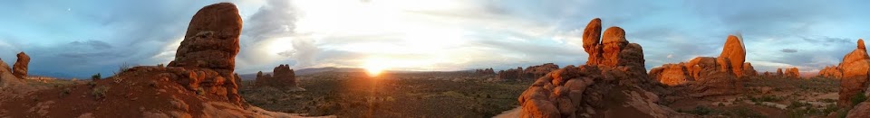
 |
| A panoramic shot of the same scene |
After leaving Arches, we drove south into the night, in order to reduce the travelling distance the next day. Before too long we reached Monticello, and soon afterwards we pulled off to stay at another campsite, just off Route 191. As we had already slept rough one night, we had no qualms about repeating the arrangement, and soon settled down for a second night in the car, this time with no hidden surprises such as canyons, lightning storms or potential murderers.
 |
| Morning over southern Utah |
The day began with oppressive cloud and there was heavy rain during our breakfast stop in the town of Blanding, but this subsided as we followed the sun towards the south, and by the time we reached Bluff, the day was glorious. We followed Route 163, a designated scenic byway, through more amazing red rock desert and the charmingly named village of Mexican Hat, until the jaw-dropping sight of Monument Valley presented itself before us. After Arches, it was hard to comprehend that any sight could be in the same league in terms of natural wonder, and yet Monument Valley defied the odds!
 |
| View south down Route 163 to Monument Valley |
 |
| One of North America's most scenic spots seemed like an ideal place to pose with the Stars and Stripes |
The turning leading to Monument Valley is still in Utah, but the visitor centre itself is in Arizona, and somewhere along the road that enters the park, we crossed the border into my fifth state. Unfortunately, the attendant at the entrance informed us that it would not be possible to access the valley floor in anything less than a 4x4, so we headed to the visitor centre to decide upon a plan. The information boards made some reference to the fact that the park fell under the Navajo Nation, an area of land returned to native Navajo control by the US government (although the exact political status of the land was unclear to me), and that Navajo people had lived here for thousands of years. The major selling point, though, appeared to be that John Wayne had filmed a number of his Western films here, and the gift shop was a virtual emporium for any avid John Wayne aficionado. Having seen just a handful of Westerns and counting the latter half of the original version of True Grit as the only Wayne film on that short list, I could not really understand what the fuss was about, especially given the sheer wonder of the enormous buttes that lay before me. These seemed to be a far bigger selling point than the fact that a genre-defining but long-dead actor had once graced this same location.
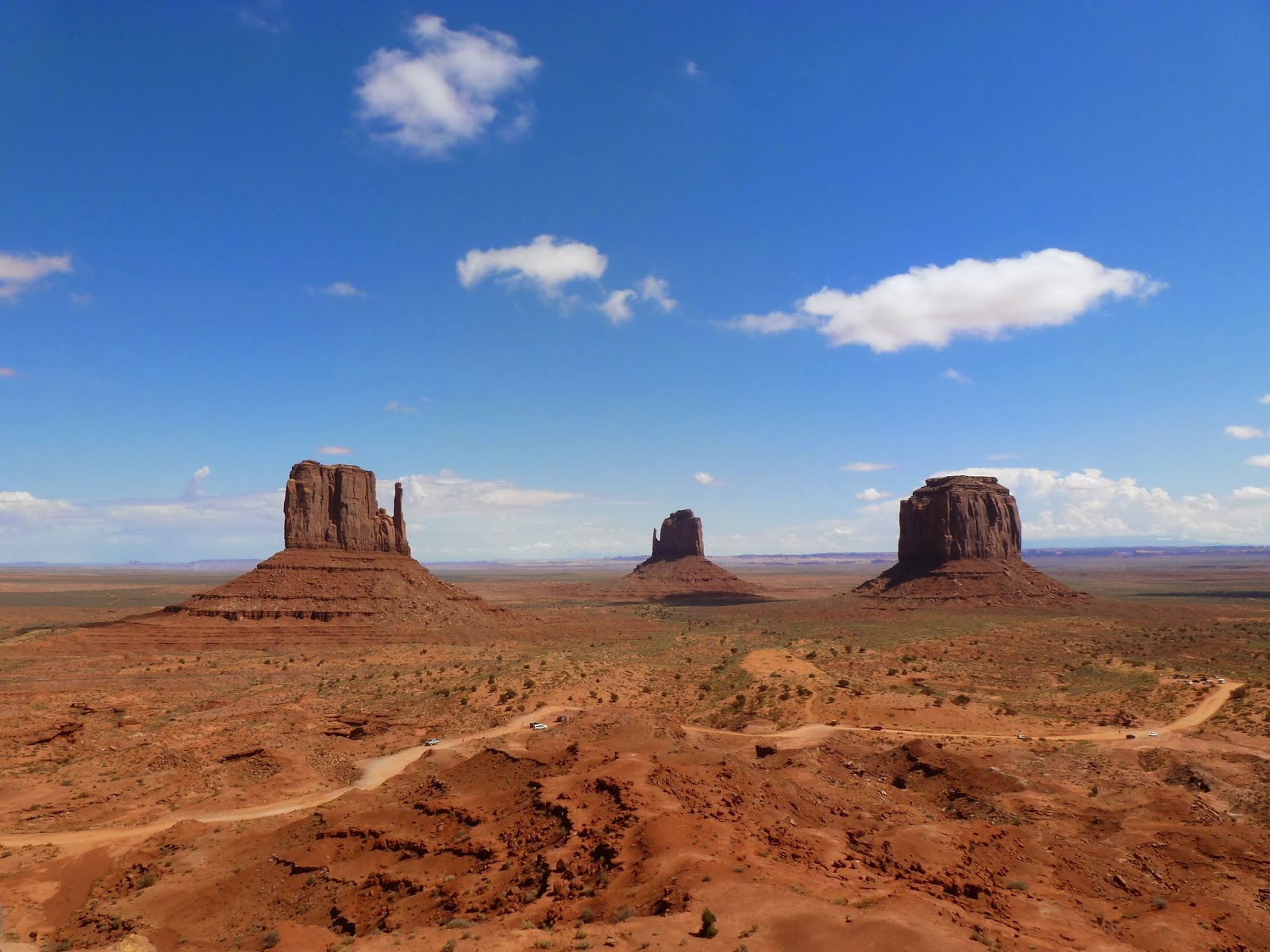 |
| The Mittens and Merrick Butte |
Seeking an alternative means of reaching the valley floor, we approached a booth advertising vehicle tours but to our horror discovered that this cost $75 for a ninety minute trip; it had only cost us $5 each to enter the park in the first place. A well-meaning tour guide then offered us a $50 trip on one of his donkeys but this was still a bit excessive considering we had aimed to drive around the valley for free. Lamenting our lack of a 4x4 we instead resorting to walking a short distance along the road but even that goal was unattainable, as a rather rude Park Ranger loudly and bluntly told us we were not to walk along the road at all. Finally we consigned ourselves to a trip along the Wildcat Trail, a short journey along a sandy path through the desert and around West Mitten Butte, one of the three large towers that dominate the most iconic section of the park. Despite our disappointment at not covering everything, the walk was very pleasant and provided an interesting perspective on an environment that was completely different even from the desert at Arches the day before. Here the sun was fiercer but the landscape was also much more biotic, with small plants littering the landscape and a variety of lizards sunning themselves on rocks, and all the while the huge buttes dominated the skyline in all directions.
 |
| Desert shrub and the three buttes |
 |
| West Mitten Butte, so called for its resemblance to a gloved hand |
 |
| A small lizard basks on the Arizona rocks |
 |
| Small cacti were strewn across the desert earth |
 |
| Hot mud peeling under the baking sun |
 |
| Hogan, the dwellings used by the Navajo people of Arizona and New Mexico |
 |
| Presiding over John Wayne Land, I mean, Monument Valley |
After a leisurely walk up to the foot of the butte and back, we moved on, firstly back into southern Utah retracing our steps along Route 163 until we turned south and entered Arizona proper. A short trip eastwards along Route 160 across the far northeastern corner of Arizona took us to our next destination, Four Corners Monument. This marks the meeting point of four large Southwestern states - Arizona, Colorado, New Mexico and Utah - and is the only location in the United States where four states meet in one place. This also marked the first occasion I actually set foot in Colorado, having previously only been inside Denver Airport and in the car whilst passing through. Unfortunately, immediately surrounding the monument was an absolute wasteland of grey gravel and scrubby plants, not beautiful as the inhospitable desert of Arches and Monument Valley had been, but merely bleak and unattractive.
The monument itself was largely a source of amusement, and most visitors were spending time taking pictures with a limb in each state, but it did also contain information boards giving an overview of the history of each state, and the flags of all the states along with the national flag and the flag of the Navajo Nation were flying above the monument. My friends and I were debating how the legal process operated within the monument since the entrance is in New Mexico, but this is the only exit in that state along a route that otherwise passes directly from Arizona into Colorado. Were we to commit murder, we would escape the death penalty provided we performed it in New Mexico. Similarly, in Colorado we could legally have smoked marijuana, whilst gambling would have been permissible in all states bar Utah. And was the portion of Arizona one hour behind the rest of the monument during summer months because Arizona does not observe daylight saving time?
 |
| Big sky over northern Arizona |
 |
| Four state here meet in freedom under God |
 |
| The four-way border itself |
 |
| Right leg in New Mexico; right arm in Arizona; left arm in Utah; left leg in Colorado |
 |
| Flag of Utah |
 |
| Flag of Colorado |
 |
| Flag of Arizona |
 |
| Flag of New Mexico, voted the best-designed state flag in the USA or Canada in a 2001 survey |
 |
| Flag of the Navajo Nation |
 |
| Border between Utah and Colorado |
 |
| Five of us in four states (and one in all four) |
 |
| Once more in four states at once |
Under the slowly setting sun, we returned briefly to Arizona before re-entering New Mexico for the final time, passing along some of the same roads that we had used just two days previously (although those two days had felt like years!) The last stop was the monumental Ship Rock, a 27 million year old remnant of an ancient volcano, lonely and isolated in the middle of a vast plain and looking like something straight out of The Lord of the Rings. We followed the rock for miles before eventually reaching a point as close as we could to it; there were scattered dirt tracks leading up to the rock itself, but these were on rough terrain and as the rock is firmly within Navajo lands it felt like trespassing to encroach any further. The rock itself is sacred within the Navajo belief system and all climbing is banned, so our view of the impressive volcanic structure was as good as we were likely to get.
 |
| Ship Rock seen from Arizona |
 |
| Viewed from the southeast |
 |
| I am sure the New Mexican sky is much bigger than in the UK; perhaps because it is blue here, not just grey! |
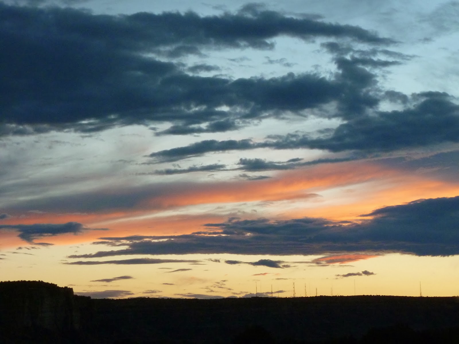
This time, we took an alternate path to Albuquerque, following Route 491 as far as Gallup, from where we took I-40 due east back to the Duke City. Gallup is one of those famous Southwestern cities along the old Route 66 and its name features in the Chuck Berry song, so it was a source of intrigue to pass through it. The Interstate provided a view down to the city, which appeared to be structured along what would have been Route 66, complete with a colourful neon array of motels, diners and petrol stations, now sadly bypassed by impatient Interstate travellers, and I could not help but be reminded of the Pixar film Cars, which tells the tale of Radiator Springs, a similar settlement in the New Mexico-Arizona area. Happily, from my external position it appeared that Gallup had not suffered in the same way as Radiator Springs, but it still seemed somewhat ignored compared to the glory days of Route 66. The next major city along the Interstate was another Route 66 stopover, Albuquerque, and the western hills provided a sparkling view of the city lights as we reached the end of our weekend away.
 |
| Subtly highlighted clouds over western New Mexico |
 |
| A third gorgeous Southwestern sunset |
 |
| Returning to the lights of Albuquerque |